

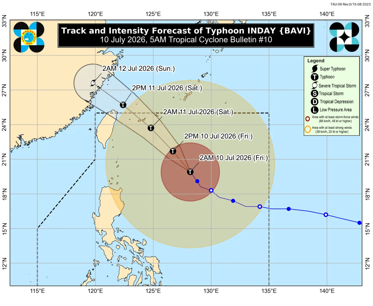
Typhoon Inday was 620 kilometers east of Basco, Batanes, moving northwest at 20 kilometers per hour as of 4 am on July 10. The typhoon's maximum sustained winds were down to 150 km/h, with gustiness of up to 185 km/h.
The Philippine Atmospheric, Geophysical, and Astronomical Services Administration (PAGASA) still expects Inday to be closest to extreme Northern Luzon between Friday night and Saturday morning, July 11. Flooding and landslides are likely in areas with moderate to heavy rain.
Heavy to intense rain is forecasted for Occidental Mindoro, with 100-200 mm of rainfall in some areas. Moderate to heavy rain is predicted for Zambales, Bataan, Metro Manila, and several other provinces. The enhanced southwest monsoon and the typhoon's periphery are also bringing strong to gale-force gusts to these areas.
The country's northernmost province of Batanes is seeing moderate to heavy rain (50-100 millimeters) due to Inday on July 10. During the day, the typhoon may also trigger rain with gusty winds in the Cordillera Administrative Region, Ilocos Norte, Cagayan, and Isabela.
And while the typhoon's wind signals have been lowered, several provinces in Luzon are still expected to experience strong winds and rough seas. Signal No. 2 Gale-force winds (62 to 88 km/h) are expected in the eastern part of Babuyan Islands, northeastern part of mainland Cagayan, and several other areas.
The enhanced southwest monsoon and the periphery of the typhoon are also causing rough seas in several seaboards. Up to 7 meters high waves are expected in Northern and eastern seaboards of Batanes, and up to 6 meters high waves in the seaboards of Babuyan Islands, northeastern seaboard of mainland Cagayan, and the remaining seaboards of Batanes.
Conditions in certain seaboards remain treacherous due to the typhoon and the enhanced southwest monsoon. Small vessels should not venture out to sea in these areas, as travel is risky for all vessels.
And as the rain pounds some parts of Luzon, several provinces are bracing for the impact of flooding and landslides. The National Disaster Risk Reduction and Management Council (NDRRMC) has issued warnings to affected communities, urging residents to stay indoors and prepare for the worst.
The Philippine Coast Guard (PCG) has also advised the public to stay away from coastal areas, as rough seas and strong winds are expected to persist in some areas until Saturday. With this weather advisory, residents are advised to stay informed and follow the guidance of local authorities.
Key Facts
- Typhoon Inday weakened into a tropical depression on July 11.
- Heavy to intense rain is forecasted in Occidental Mindoro, Zambales, and Bataan.
- Moderate to heavy rain is predicted in several other provinces, including Metro Manila.
- The enhanced southwest monsoon is expected to bring strong winds and rough seas in several seaboards.
- Flooding and landslides are likely in areas affected by the rain.
- Residents are advised to stay indoors and prepare for the worst.
- Small vessels should not venture out to sea in affected areas.
- The NDRRMC has issued warnings to affected communities.