

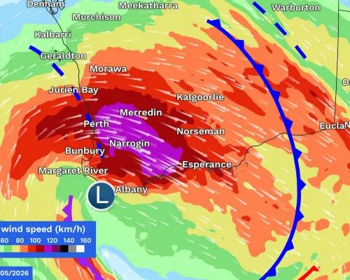
'Significant' Storm System Hits Western Australia
A major storm system is bearing down on millions of Western Australians on Saturday, bringing cyclone-strength winds and a 'wintry blast' to the east of the country. Wind gusts exceeding 125km/h are possible in the populated south-west.
Daniel Hayes, a meteorologist at the Bureau of Meteorology, warned residents in Western Australia's south-west to tie down loose items and prepare for destructive wind gusts from Saturday evening. Hayes said this storm system 'looks quite significant,' with a deep low-pressure system moving towards the WA coastline, dragging tropical moisture with it to bring heavy downpours and strong winds.
A Bureau of Meteorology warning covering the entire south-west of WA is in place, advising residents to prepare properties and stay away from surf and exposed areas. Residents can expect six-hourly rainfall totals of up to 60mm in central west areas from late Saturday until early on Sunday, while the entire south-west coastline is under a warning for abnormally high tides and damaging surf.
Wind gusts of 50km/h are forecast for Melbourne on Monday evening. Hayes predicts the system's connection to tropical moisture will break down as it moves east, reducing the amount of rain it could bring. However, the southern two-thirds of the country will be warmer than average, according to the bureau's long-range forecast.
The phenomenon of El Niño is being closely watched by meteorologists, who say it can push up global temperatures. When combined with global heating, this storm system could see 2027 become the hottest year on record, according to experts.
Key Facts
- Six-hourly rainfall totals of up to 60mm are predicted in central west areas of Western Australia
- Wind gusts exceeding 125km/h are possible in Western Australia's populated south-west
- Abnormally high tides and damaging surf are expected along Western Australia's south-west coastline
- Wind gusts of 50km/h are forecast for Melbourne on Monday evening
- The southern two-thirds of the country are expected to be warmer than average this winter
- The system could lead to 2027 becoming the hottest year on record due to global heating and El Niño
The storm system is expected to move east, bringing icy weather to NSW, Victoria, and SA. It's set to feel noticeably cool with strong winds, Hayes said. Once the front moves through, residents in these areas can expect a pronounced wintry blast.
As the system moves east, Hayes predicts the connection to tropical moisture will break down, reducing the amount of rain it could bring. A second round of wind gusts up to 125km/h are expected on Sunday night between Lancelin and Albany, including Perth. Low-lying areas could see flooding, and residents were warned to stay away from surf and exposed areas from Sunday morning.
Residents in South Australia and Victoria will likely be under further warnings by Sunday as the system moves east. Hayes said both states can expect similar weather conditions to Western Australia, with wind gusts and heavy rain expected.
The storm system is expected to peak on Monday, with the strongest winds and heaviest rain expected during this time. Conditions will be particularly rough in Western Australia, with residents in the populated south-west warned to tie down loose items and prepare for destructive wind gusts.
Residents in Western Australia were advised to stay indoors and keep up to date with the latest weather warnings. A Bureau of Meteorology spokesperson urged everyone in the affected areas to stay safe and follow all instructions from local authorities.
The storm system is set to bring icy weather to NSW, Victoria, and SA, with wind gusts and heavy rain expected in each state. Residents in these areas were advised to stay indoors and keep up to date with the latest weather warnings. The Bureau of Meteorology spokesperson once again urged everyone in the affected areas to stay safe and follow all instructions from local authorities.
Hayes said the system's connection to tropical moisture will break down as it moves east, reducing the amount of rain it could bring. The storm system is expected to peak on Monday, with the strongest winds and heaviest rain expected during this time. In South Australia and Victoria, residents can expect similar weather conditions to Western Australia, with wind gusts and heavy rain expected.
Residents in South Australia and Victoria are advised to stay indoors and keep up to date with the latest weather warnings. The Bureau of Meteorology spokesperson urged everyone in the affected areas to stay safe and follow all instructions from local authorities.
The storm system will bring heavy rain and strong winds to NSW, with Hayes predicting the system's connection to tropical moisture will break down as it moves east. This development is expected to reduce the amount of rain it could bring to the region.
Hayes repeated his warning about the storm system's potential to bring rough conditions to Western Australia, particularly in the populated south-west. Residents in this area were advised to tie down loose items and prepare for destructive wind gusts. The Bureau of Meteorology spokesperson once again urged everyone in the affected areas to stay safe and follow all instructions from local authorities.
The storm system is expected to bring icy weather to NSW, Victoria, and SA, with wind gusts and heavy rain expected in each state. Conditions will be particularly rough in Western Australia, with residents in the populated south-west warned to tie down loose items and prepare for destructive wind gusts.
Residents in Western Australia were advised to stay indoors and keep up to date with the latest weather warnings. The Bureau of Meteorology spokesperson urged everyone in the affected areas to stay safe and follow all instructions from local authorities.
The storm system is set to bring heavy rain and strong winds to NSW, Victoria, and SA. Hayes said the system's connection to tropical moisture will break down as it moves east, reducing the amount of rain it could bring. The storm system is expected to peak on Monday, with the strongest winds and heaviest rain expected during this time.
In South Australia and Victoria, residents can expect similar weather conditions to Western Australia, with wind gusts and heavy rain expected. Hayes said the conditions will be particularly rough in these states as well.
Residents in South Australia and Victoria are advised to stay indoors and keep up to date with the latest weather warnings. The Bureau of Meteorology spokesperson urged everyone in the affected areas to stay safe and follow all instructions from local authorities.